The maps below show a beachfront area in Australia in 1950 and today. Summarise the information by selecting and reporting the main features and make comparisons where relevant.
Sample Answer of The Maps Below Show a Beachfront Area in Australia in 1950 and Today
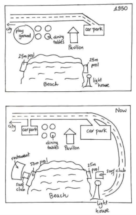
They yielded two maps that demonstrate a beachfront area in 1950 and presently in Australia.
Overall, the major changes are surrounding the beach where clubs and restaurants open now and the new road is made.
In 1950, a car parking road was connected to city road and alongside that road was round shape play ground and dining tables. There was two same dimensions pool, and one was on the east side while another was on the west side of the beach. The pool was 25 meters long. Additionally, one pavilion was between car parking and dining tables, a small lighthouse beside the east pool.
Currently, we can see dramatic changes, primarily in the road. Now the road is not ending at car parking. It developed to the lighthouse, and it’s in u shape. No change for dining tables and pavilion; however, small car parking takes the place of the playground. Another car park area is increased on the southwest side, pool dimensions double than 1950, and open restaurants. One new advancement surf club is the backside of 50m pool, and one is the 25m pool backside.
Follow Us on IELTSFever Instagram for more Updates And the Latest test tasks.
Also, Read TIP (1) ACADEMIC WRITING TASK 1 AND 2. The writing component.