The map depicts the present condition as well as improvised plan of a specific area. Summarise the information by selecting and reporting the main features and make comparisons where relevant.
Sample 1: The Map Depicts the Present Condition as Well as Improvised Plan of A Specific Area
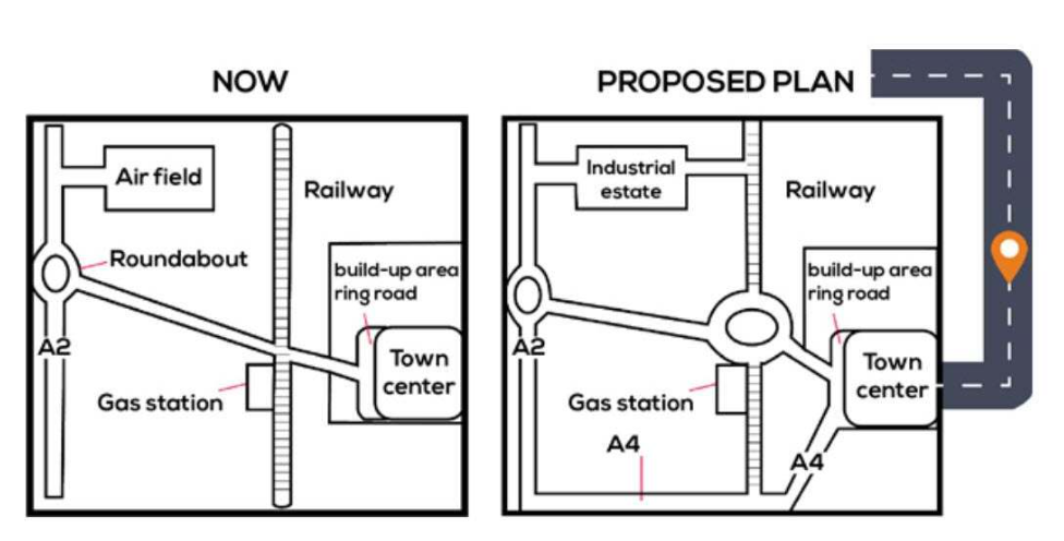
The given two maps illustrate information about the present city structure. And how it will be when some new areas are developed. Overall, the maps reveal that they will build roads that connect some areas and construct new roads outside the town.
First, on the first map, there is the town centre and build-up area on the east side of town. And a ring road connects other areas of the town centre. On the northeast side, there is one railway, and on the opposite side, an airfield is connected to the A2 road. Build-up area ring road that is connected to the railway track and roundabout of A2 road. Beside the railway track on the south side, there is a gas station.
On the second map, on the outside of the hometown, they will create one highway. That will connect the town centre to other towns. A new roundabout will be created beside the gas station, connecting all three railway tracks and the build-up area ring road. On the south side, they will construct a new A4 road that will connect the town centre, railway road, and A2 road together. Finally, they will remove the airfield and construct a new industrial state that connects the A2 road and the railway road.
Sample 2: The Map Depicts the Present Condition as Well as Improvised Plan of A Specific Area
The map depicts the present condition as well as an improvised plan of a specific area. After reconstruction, many changes can be witnessed in different parts of the area.
At first glance, an access road along the south to North directly goes to the airfield in the North-west part. There is a roundabout which has joined to the railway track. A large area on the right side of the railway track can be seen, in which the town centre can be found. The remaining areas are vacant as the build-up area ring road is in front of the town centre. Furthermore, a gas station is available on the left side of the joining track.
According to the updated map, the road track will be constructed and joined from the southern and Northern sides as an industrial estate replaces the airfield. Which directly joined the road and railway track. Likewise, the roundabout will be constructed on a joint part of the road and railway track. On the other hand, A4 Road will be joint to the town centre from south-east side.
Discover more from IELTS Fever
Subscribe to get the latest posts sent to your email.