The diagrams below show the changes that have taken place at west park Secondary school since its construction in 1950. Summarise the information by selecting and reporting the main features and making comparisons where relevant,
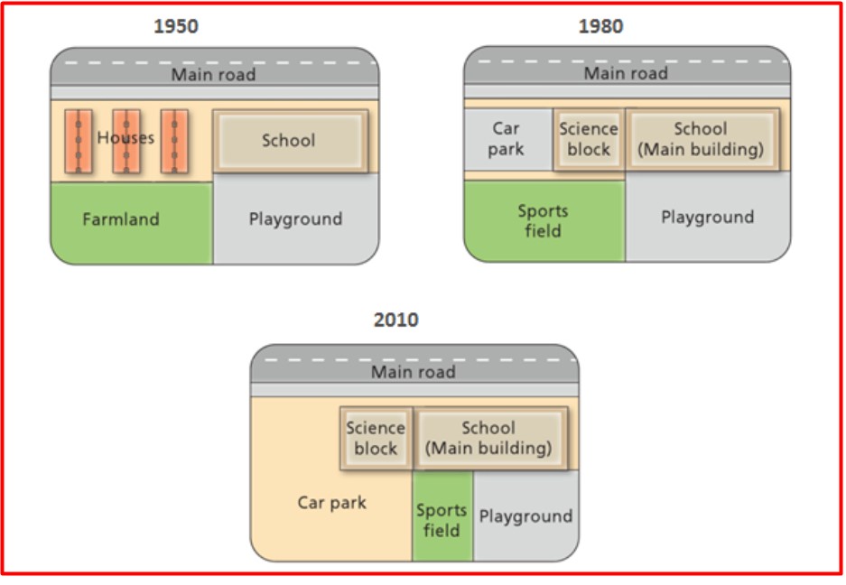
The diagrams illustrate the alterations that have been effected at West Park Secondary school since it was constructed in 1950 to the year 2010. Overall, the location of the main road remained unchanged throughout the given years given. However, they were eradicated and replaced by different structures.
To begin, in 1950, the location of the main road was situated along the northern border of the layout, and this remained unchanged both in 1980 and 2010. Again, the residential site and farmland which used to be located on the left-hand side of the town were removed and replaced with a quite smaller car pack and a much bigger sports field found in the southwestern part of the town in 1980; meanwhile, in 2010, the already mentioned portion was substituted with a much larger car parking area featuring a much smaller sports field.
Additionally, the school building used to be much smaller in 1950 as compared to similar views in 1980 and 2010 with an extension that included the addition of a science block. The playground which was found in the south-east corner of the town still remained the same in 1950 and 1980, but with the 2010 plan, the size was somehow smaller.
Follow Us on IELTSFever Twitter for more updates
Discover more from IELTS Fever
Subscribe to get the latest posts sent to your email.