The maps below show Pebbleton 20 years ago and today. Summarise the information by selecting and reporting the main features, and make comparisons where relevant.
 Sample 1:- The Maps Below Show Pebbleton 20 Years Ago and Today
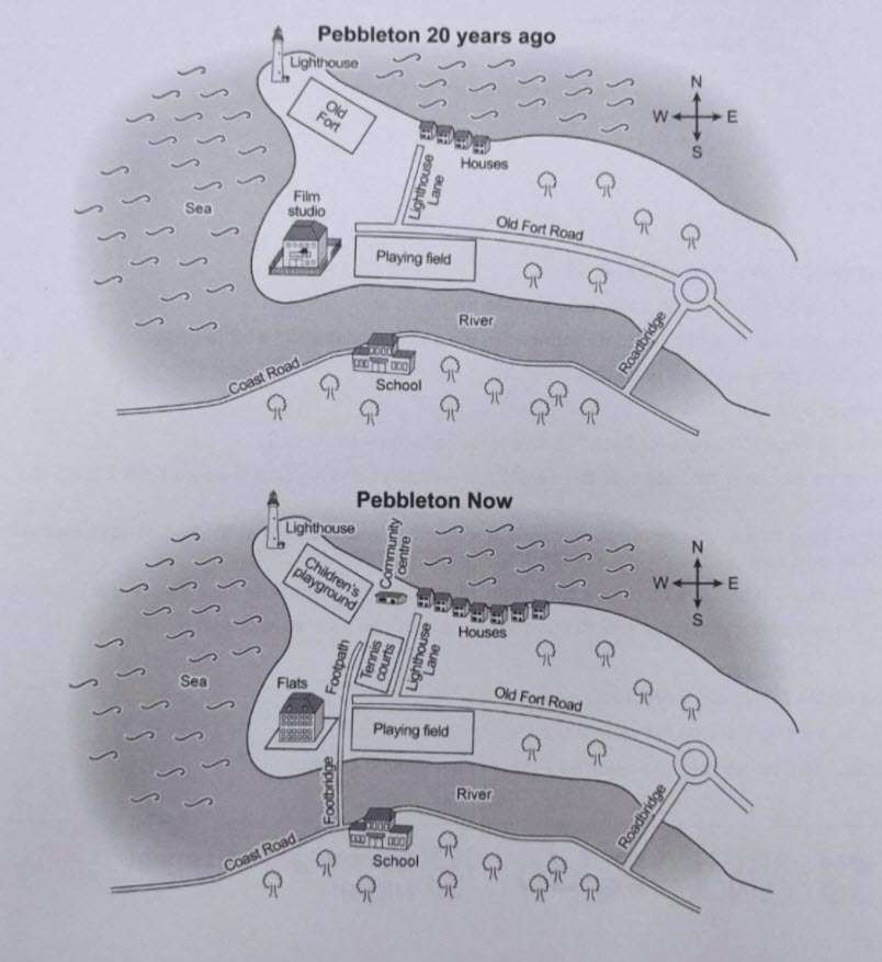
The yielded maps compared Pebbeton 20 years ago and how it looks nowadays. Overall, it can be seen that in two decades, this place became more residential and made few changes for better amenities.
Twenty years ago, the north had houses, and the south direction of it was the lighthouse lane. In the centre, West to the east passed an old fort road. In the northwest corner, the place was for a lighthouse alongside the old fort in the opposite direction.
The playing field was on the corner of the river, and a film studio was n the West following the road. Additionally, a road bridge was the only way to go to school on another side of the river.
Presently, opposite the side of the lighthouse lane, new tennis courts took place—several houses in the north rose. The lighthouse’s location remained the same, although the children’s playground took the position of the old fort, whereas Flats took the site of a film studio, also reconstructed.
Moreover, a new foot road was constructed for going to school, which passes between flats and a playing field and joins the coast road.
Sample 2:- The Maps Below Show Pebbleton 20 Years Ago and Today
The development map illustrates the remarkable information regarding the development of Pebbleton in 20years ago and at present. Looking into the overall perspective, it is clearly seen that there are few changes in the present map as compared to the old one.
Highlighting the giving presentation, 20 years ago, there was a lighthouse in the West corner which is also available on today’s map. But, the old fort changed with a children’s playground as well as there were few houses in Pebbleton 2 decades ago. However, at present, the number of houses is newly built. In the centre of the west-to-east direction passed a road which was known as old fort road along with the lighthouse line.
Moving to the rest of the changes, it can be seen that the film studio is converted into flats. Most interestingly, the sea, river, playing field and schools are in the same place as they were before 20 years. There are also a lot of trees along with coast road, and also the bridge is also in the same place as it was before.
Follow Us on IELTSFever Instagram for more updates and the latest test tasks.
Also, Read The Chart Below Shows the Top Ten Countries With The Highest Spending
Discover more from IELTS Fever
Subscribe to get the latest posts sent to your email.


The two maps given reflect the changes in Pebbleton for a period of 2 decades.
Generally, there were no major improvements in the place except for the new tennis court, community center, and the footbridge which connects the school and the playing field.
Over the 20 years, the old lighthouse remained as well as the playing field, the forest, and the road bridge. Few more houses were constructed in the community.
However, few renovations were made. The old fort became the children’s playground and the film studio was made into flats. The new footpath was made along the tennis court leading to the community center.