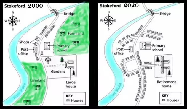
The maps beneath show the town of Stokeford in 2000 and 2020. Sum up the data by choosing and covering the primary capacities and make correlations where suitable.
The yielded Mapes reveals Coleford’s town in 2000 and 2020.
Overall, it can be clearly seen that after two decades, the town is more residential area. The farm field was also removed.
In 2000, in the south-west corner to north-east corner one river passed and in the centre has a road, where road cross-river there had a bridge. Alongside roads housed built, shops and post office was opposite of primary school which was the centre of road and farmland. Another farmland was on the south side. One large house was followed by farmland and surrounded by trees and a garden.
In 2020, the river, road and bridge remained the same as was two decades ago. There was no farmland area which removed. The number of houses climbed, in some places new colony developed. The place of primary school was unchanged although, it was modified. Fans or walls and gardens of the large house were removed, and this place was known as a retirement home. Furthermore, the post office was still on the same spot, but Houses took shops.
Follow Us on IELTSFever Instagram for more updates and the latest test tasks.
Also, Read The Pie Chart Gives Information About the Country of Birth of People
Discover more from IELTS Fever
Subscribe to get the latest posts sent to your email.